

DomusTerra is a low-cost program for architectural land modeling. DomusTerra springs from Interstudio’s vast experience in the land modeling and representation sector, begun in 1988 with the first release of Nonio C.
DomusTerra has all the characteristics of its big brother Nonio C – interactive modeling, walkthroughs in real time, supports textures, supports plug-in renderers – with some limitations regarding direct plotting, modeling and allowable number of points. While Nonio C is best suited for more elaborate surveys and for modeling large tracts of land, DomusTerra can be used for small and medium projects and architectural landscaping.
A land model created with DomusTerra can be exported to an architectural program, such as Interstudio’s own Domus.Cad or Graphisofts ArchiCad, where it may be viewed and elaborated along with the architectural model. The reverse operation may also be performed: an architectural model may be imported to DomusTerra (in QD3D MetaFile format) where it can be placed directly on the modeled landscape.
DomusTerra imports and exports in Domus.Cad, GDL, DXF 3D, 3DS, 3D MetaFile, and DigiCad 3D formats.
No demos of DomusTerra are available but you may download the new Nonio C trial program.
Terrain is modeled using a method of triangulation, a valuable alternative to methods based on the generation of an orthogonal grid, which does not often correspond well to real-life conditions. Two surfaces can be modeled simultaneously, allowing the comparison of the original terrain with the modified or of two different project phases.
Points data may be inserted using the keyboard, an image, field survey, or ASCII file.The model is created either automatically or by imposing breaklines interactively with the mouse, recreating as closely as possible a representation of the actual terrain. Contour lines are drawn automatically according to set intervals.
Once the necessary data is entered, the land model may be altered by simulated land movement operations. Values such as areas, volumes, and slope differences are computed automatically by a special calculator.
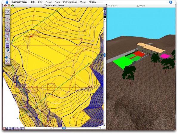 DomusTerra screen shot
The model can be viewed from any vantage point through a series of automatically generated images (sections and axons). The images can be drawn in a variety of representational forms (with contour lines, in cross-grid form, or with shadings, hatchings, or color according to slope classes).
All modifications can be seen in real time in a continuously rendered 3D view. It is possible to fly around the terrain or do a “walkthrough” in real time. The rendering can be enhanced using plug-in renderers. Textures may be imported to the QuickDraw 3D view to simulate materials or soils. Movement throughout the model is controlled using the mouse or keyboard.
A land model created with DomusTerra may be exported to an architectural program, such as Interstudio’s own Domus.Cad and other CAD programs, where an architectural model may be placed directly on it. The reverse operation may also be performed: an archiectural model can be imported by DomusTerra and placed on the land model.
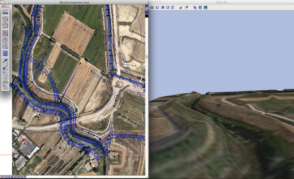 Terrain with a GoogleMap image as texture
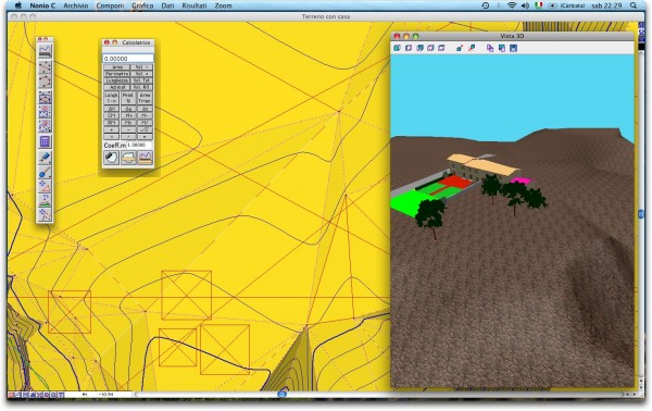
DomusTerra with an architectural model imported from Domus.Cad
DomusTerra
supports documents of up to 3000 points
imports in XYZ ASCII, DWG 3D, DXF 3D and QuickDraw 3D MetaFile formats
exports in Domus.Cad, GDL, QuickDraw 3D and Quesa MetaFile.
Imports textures
supports plug-in renderers
supports Drag and Drop for textures, text, and images
two surfaces may be worked simultaneously
automatic generation of triangles, contour lines, and surfaces
allows direct intervention of model using break lines
vertical sections from polygons
special calculator for surface and volume calculations
integrates Domus.Cad information
Raster images modification (rotation, scaling, resolution, colors and transparency)
Z moving of the selected points. Two new modeling functions allow you to modify the Z axis of your model in selected points, either by inserting the new measurements or by using the mouse.
Correction of maps deformations. This is useful for correcting deformations in map supports, which frequently differ in X and Y directions.New interactive modeling function, using mouse to move selected points vertically or horizontally. All windows, contours, colors, sections and 3D views are updated real time.
Breaklines introduced by mouse intervene immediately on terrain , canceling old triangles and adding new ones.
Multiple undo/redo – up to ten stages back.
Universal Binaries. The Macintosh version is Universal Binaries, optimizing new processors.
3D palette window for View and Save functions.
New rendering motors (OpenGl, Cartoon and Hidden Line) plus improved RayShade.
Drag and Drop for all images and textures recognized by QuickTime.
Imports/exports 3DS format, in addition to DXF, 3DMF, GDL, XYZ, etc.
..and many more, such as mighty mouse and mouse wheel, new triangulation routine, importing images to scale, blocking background images, etc.
-
Characteristics DomusTerra
Nonio C
Imports in XYZ ASCII, DWG 3D, DXF 3D, 3DS and QuickDraw 3D MetaFile formats X
X
Allows direct intervention of model using break lines X
X
Automatic generation of triangles, contour lines, and surfaces X
X
Two surfaces may be worked simultaneously X
X
Vertical sections from polygons X
X
Special calculator for surface and volume calculations X
X
3D display of the model X
X
Support of QD3D and Quesa interactive rendering and MetaFile X
X
Supports Drag and Drop for textures, text, and images X
X
3DMF import X
X
DXF 3D import X
X
DEM import X
X
Export GDL, DigiCad 3D, Domus.Cad, QD3D MetaFile, 3DS X
X
DXF export X
X
Raster images modification (rotation, scaling, resolution, colors and transparency) X
X
Configurable unit of measures X
X
Text reports and images export X
X
Integrato con Digicad 3D, Nonio A, Geo-Tec C e Domus.Cad X
X
Simulating digging and filling operations X
Automatically superimposes two land models X
Max number of points 3.000
500.000
3D real time walkthrough X
X


